My godparents’ place near Cunault, on the south bank of the Loire, has a maze of artificial caves underneath it, the remains of an old limestone quarry. These are very common in the area – the lovely white limestone manoirs and chateaux here were built from the stone directly underneath them, and stone was also exported up and down the river to nearby towns.


This one in particular we think is mostly 19th and 20th century, although some of the evidence we found might go back to the 1780s. Some of the local caves were used by resistance fighters as hideouts, but we’ve got no reason to believe this one was. After the war, it was used to grow mushrooms (using manure from the nearby cavalry school at Saumur) until cheap Polish imports rendered that uncompetitive. A group from a bat conservation society did a pass some time ago but didn’t record the actual layout. So that was my project.
Methodology – I looked at various cave-mapping resources designed to make incredibly detailed maps (many in three dimensions.) and felt them overkill. Instead I used a very simple approach:
- At each junction, write down and place a piece of paper giving the number of the junction and the direction you’ve come from, to always have a pointer home.
- Take the left-hand passage.
- Count steps until the next junction and repeat from 1).
- If you reach a dead end, retrace back to the last junction and take the next from.
I would end up with a topographical map (more like the London Underground) rather than a perfectly accurate one, but that’s basically what we needed.
Equipment: Being alone and not particularly wanting to die in pitch blackness, I had a pencil torch, a headlamp for reading the map, my phone torch as a backup and a hand-crankable torch as a backup backup. We improvised a clipboard from a piece of hardboard and two bulldog clips, and I took a crayon to mark junction sheets and a biro to draw the map. For my first expedition, I wore a jumper and jacket and carried a bag with food and a water bottle. This was totally surplus to requirements, the cave being a fixed temperature with still air, and I did the rest in my shirtsleeves!
Expedition I


Explored up to Junction 14. Got a general sense of the journey as a wide sweeping semicircle, with a lot of dead-end shafts about 25m long on the eastern (?) side, including one full of salty mud. Reached a vent to the surface – think it’s the one on J&S’s land but not sure; there was an actual hump on the ground of fallen dust and dead oak leaves. Some interesting graffiti and tally marks with pre-WW1 dates; some little clear pools of water, one area north of the vent where water’s dripped out of the ceiling and made lots of tiny holes in the floor. Otherwise mostly dry, wide passages, mostly tall enough for me to stand up in. It didn’t actually feel too oppressive alone in the dark down there, but gosh I’ve never seen as warm and wonderful a sun as when I emerged.
Expedition Ia


Went up to the vent in the hill above the house and tossed a log marked with green paint down to make sure it was the same vent. (Turns out it was!)
Expedition II


Found the green log at J13 and proceeded on to J26 including through some quite cramped, difficult tunnels. Found a tally from the bat people and determined that there is indeed a complete circle underground. Most interestingly, went down a long side passage at J21 and found – as well as a lot of fun graffiti and some carved crucifixes – a portrait of a gent with a pipe.

Expedition III


Mapped the full outer circle properly (J27-29) and discovered on returning to the J3 turnoff there is another large internal circle (J30-42). Previously placed markers had gone a bit soggy in the ambient humidity. Near a couple were some of millipedes, a couple of inches long and the same light tan as the earth – the only sign of life down there. We may need a more durable form of junction marker. Found a bunch of mounds of earth which I assume are for growing mushrooms rather than being the last resting place of various Maine-et-Loire mafia hits. Not digging into them to find out.
Expedition IV


Expecting mainly to deal with the dead ends at J10, J19, J26, J28 and J30, almost all places I looked at and went “nope” to on previous expeditions. As it turned out they were mostly fairly simple, with one very cool passage past J46 where hundreds of tiny stalactites had formed and dripped glittering crystal over the rocks beneath them (first video on this post). Took a closer look at the pile of stuff off J27 – looks like infill from above (wonder where?) with some tiles on the side of the chamber which are very plausibly asbestos. As long as I don’t rub my face onto it I should be OK, right? Emerged into the light to consolidate my notes at length with cheese and wine.
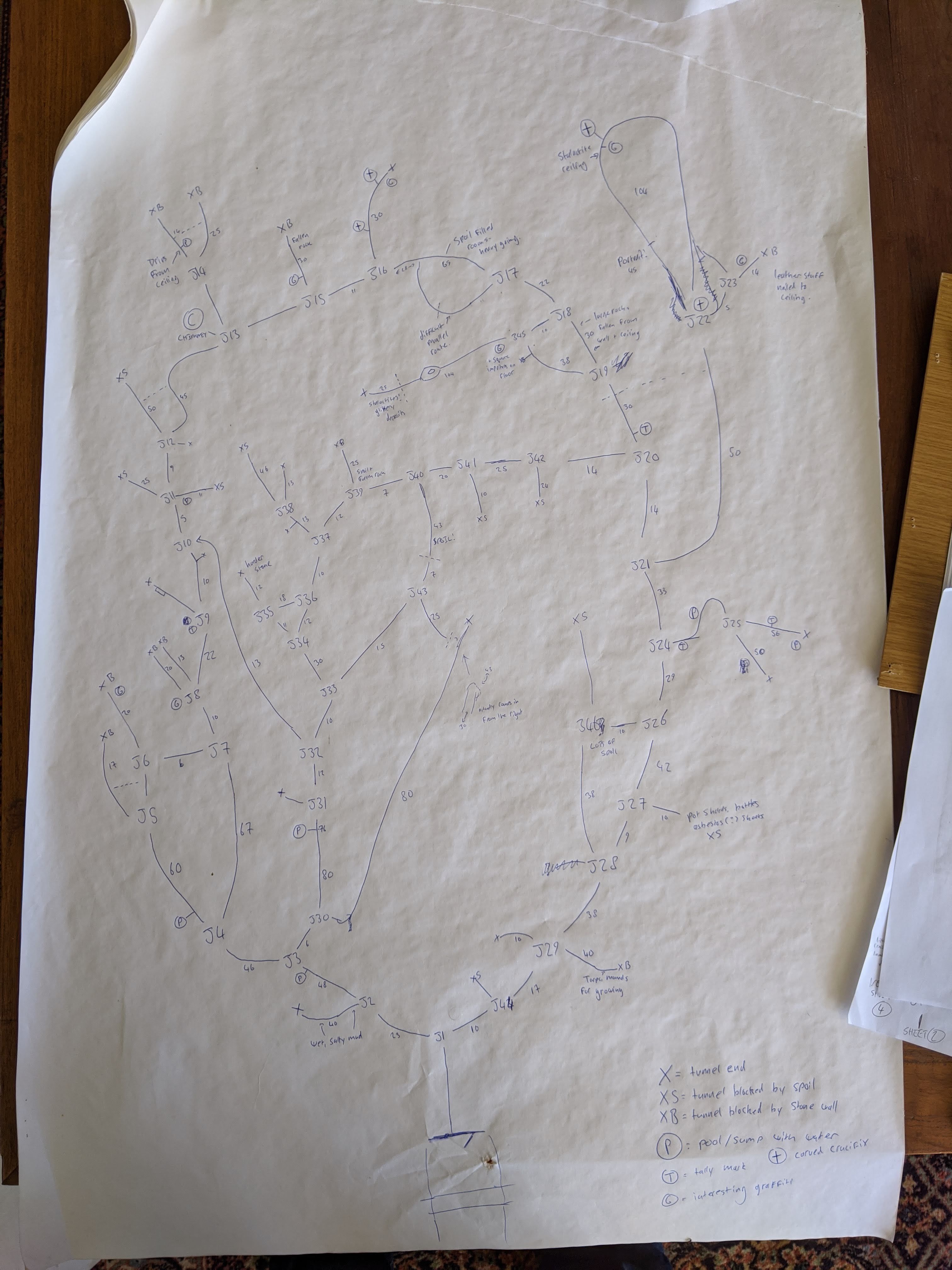
I’ll leave it to my godparents (who are architects and can actually hold a pen) to reduce this into a useful format, and they’re talking about putting down little ceramic tiles as junction markers. We will, in the end, need 46 of them…
