This is the second part of a trip around the Medway estuary in the summer of 2019. The first half is here. As ever, click the pictures for full-size versions.

We fortified ourselves with sweets and Irn Bru and set out north and east to Hoo: a low-lying tongue of land between the Thames and the Medway, fringed by tidal marsh. It’s a weird, windswept, empty landscape – there are very few trees, so only low scrubby bushes obscure the cyclopean structures that loom on the horizon, made more intimidatingly huge by their distance: a rank of cranes, a clutch of gigantic storage tanks, a petrogas* power station, an Amazon fulfillment centre. A place of low land and low land values, populated by big, cheap things which London needs but doesn’t need to see. We parked the car on a stub of unfinished roundabout and found the Bee Ness jetty.
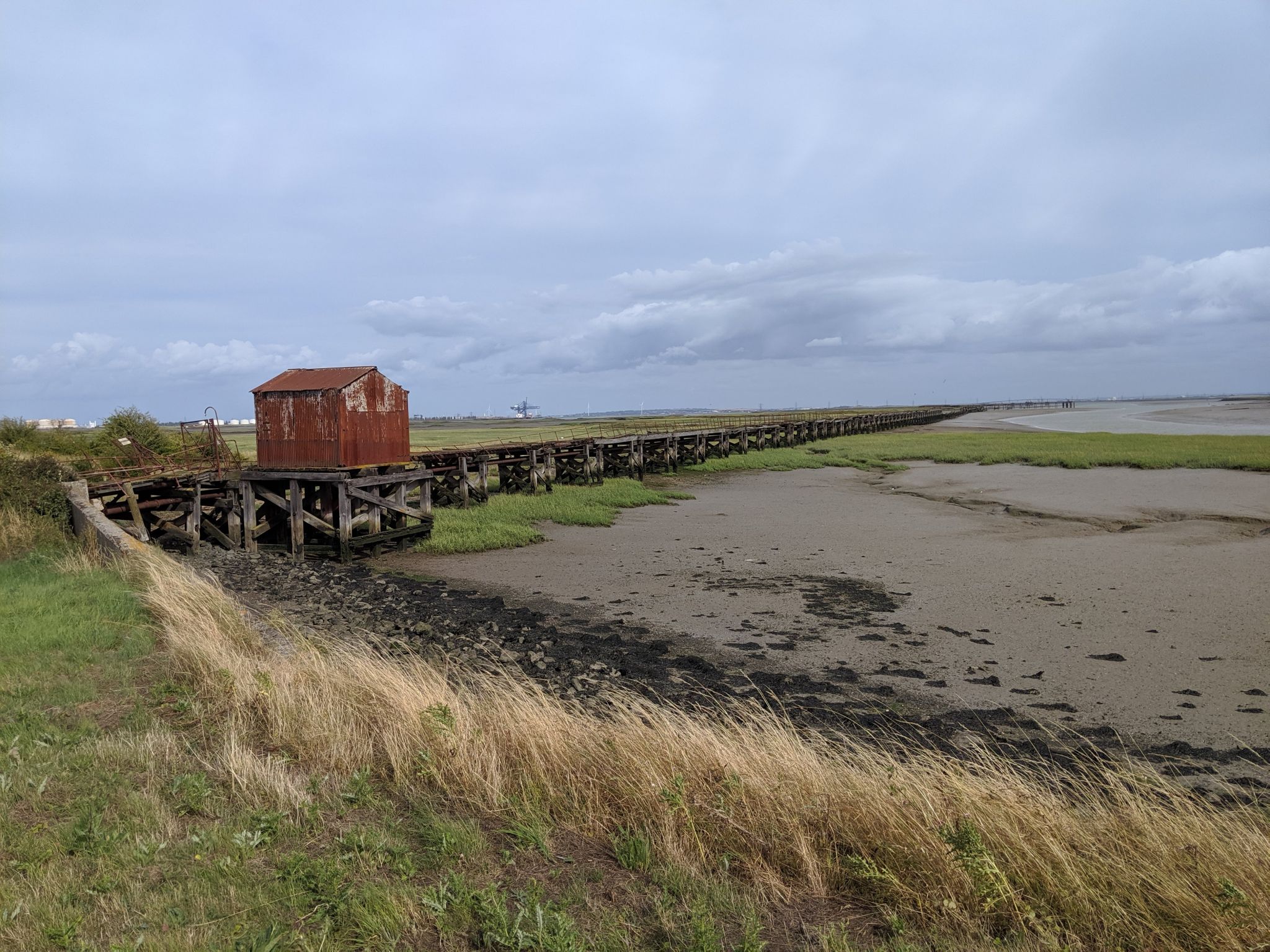
The jetty is an oil pier, the last surviving piece of a 1930s refinery ruined by the 70s oil crisis and now no longer extant. (There were once quite a few more of these on Hoo, and you can still see
the ghosts of their storage tanks from aerial photography.) It’s a huge spur of steel pipes overlaid by wooden planks, sticking out into the Medway via two and a half kilometres of dense mud flats so deeper-draught oil tankers could unload directly. The gate at the base of the pier rusted off its hinges long ago, but a formidable patch of brambles has replaced it as the pier’s protection; getting around it required a funambulesque encounter with an 8″ wide sea wall, enough of an obstacle to keep things interesting but not enough that I wasn’t on the pier in two minutes, investigating the contents of the shed at the pier’s base – an antique bit of wiring and the wreckage of an old cork life ring.
I strolled along the pier itself, but quicky encountered a section of missing planks, which turned the experience from “excitingly rickety” to “unacceptably dangerous” (and, not much further along, “awkwardly underwater”), so
I didn’t proceed further. There’s a wrecked U-boat somewhere out in the marshes, but we didn’t have a hovercraft to get us there.

We continued east to the coast and the village of Grain.
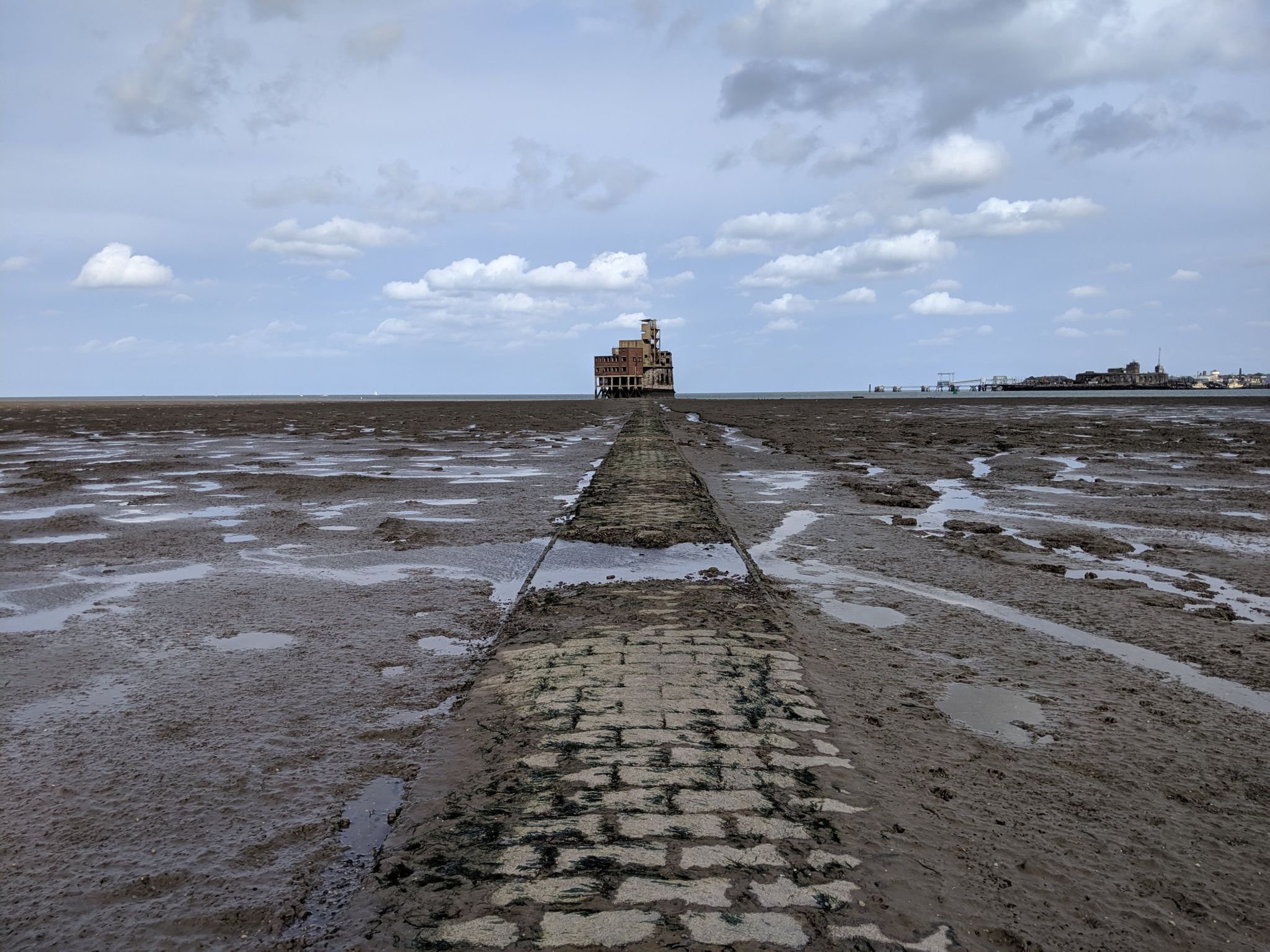
Grain Tower, like a pocket-sized knockoff of Mont St Michel, is reached by a causeway across a tidal mud flat: the causeway is made of wide, rough-grained bricks secured into their mortar by diamond-shaped undersides, except where it isn’t and is just mud. The Tower itself is a small but solid example of the “Palmerston forts”, whose frowning granite gunports and cast-iron shutters are scattered all over the Channel coast. Like many of its siblings, it has some extensions slapped together in a hurry during the World Wars; a brick barracks on stilts and rickety-looking concrete observation post leave the tower looking like it’s wearing a backpack and a stupid hat. There’s no ground-level access (it would be sea-level at high tide), but some kind soul had secured an aluminium ladder with a loop of plastic rope, next to an enormous barnacled chain wrapped around the tower’s base, which was once a boom chain running to the Garrison Point fort at Sheerness, cutting off the mouth of the Medway.
The Tower is clearly regularly visited by local kids, with its fair share of graffiti and litter; the Victorian gunports are blocked up, and there are more modern shell hoists to feed the familiar QF gun emplacements on top. The main emplacements are brick and fine Edwardian concrete; later embellishments, including the highest tower, are the usual crummy just-good-enough WW2 invasion panic stuff, and look like they’ll fall apart within the next few years. The safety railings have rusted away to the point of being safety hazards all by themselves. From the top of the tower, the sunlight make the mud flats shine a filthy silver, the causeway cutting clear through them the half-kilometre back to land.
Back at the sea wall, we headed north looking for the remains of Grain Fort, and were largely disappointed. There are a few more WW2 observation posts and some concrete semicircles that were once gun positions. There’s a huge tunnel network in quite good nick still under there somewhere, but we didn’t feel like going for the beer-can-strewn possible-entrance we found, and the defensive ditches are so overgrown as to be abstractions. On the horizon, way out to sea, we could see a cluster of vague dots: the Red Sands sea forts.
Heading back inland, we passed the obnoxiously medieval gatehouse of
Cooling Castle, which was structurally curious enough back in the 14th century when it was next to the river, rather than being separated from it by kilometres of marshland. We couldn’t read the copper inscription which made us think that the the tower at least was original rather than Victorian reimagining.** Apparently Jools Holland lives there now; the barn advertised itself as a wedding venue. Imagine.
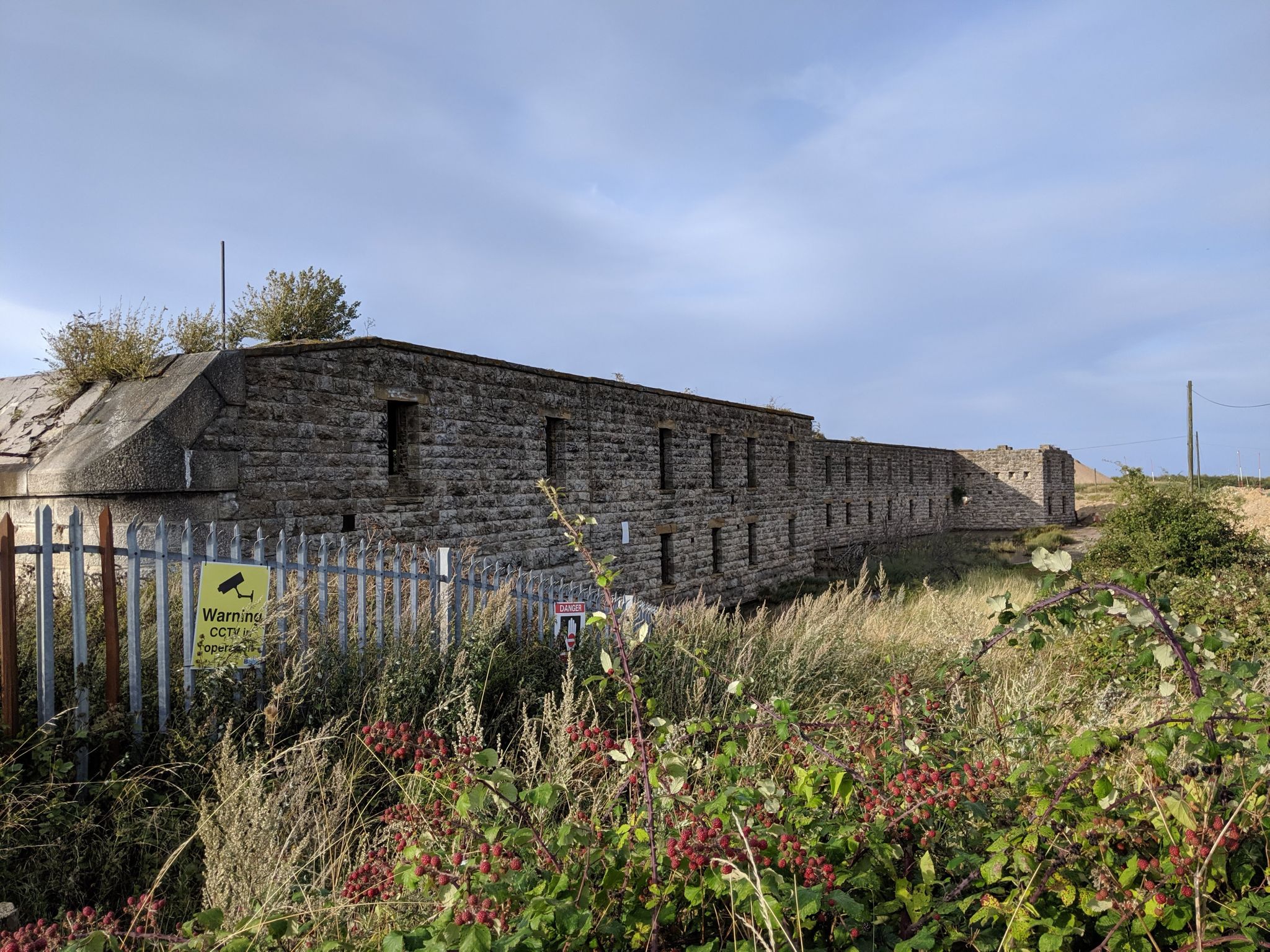
I really hadn’t appreciated quite how many ruined, forgotten forts there are guarding the approaches to London. Cliffe, paired with Coalhouse (another post on that later), is another of the Palmerston-era ones, mucked around with during the World Wars: large, ambitious, and sinking gradually into the marsh, a slightly updated version of the old cautionary line about building a castle on sand. There’s a gravel quarry built around it now, and we took a long walk alongside a huge, still conveyor belt, watching the interplay of hawks and bunnies in the flatlands around and enjoying a series of bloodcurdling signs about the dangers of gravel pits. Another rickety WW2 addition reared above the fort’s huge stone shoulders.

The fort is fenced off and meant to be inaccessible. In the matter of Victorian gun forts that normally means “challenge accepted” to me, but we were quite tired from a full day of Exploring, and the barking dog of a quarry security contractor who shouted at us to stick to the path in broken English and the half-sunken fort looked genuinely difficult. Fortunately, there were some very interesting accessible curios: the wooden guts of a derelict ship and the launch rail of a
Brennan torpedo, a curious Victorian guided weapon powered, counter-intuitively, by pulling two wires out of its rear end at high speed.
(The odd jumbled concrete structures in the background of the last photo are actually the footings of the old Nore sea forts, dragged back up the Thames and demolished in the late 50s.)
Our exploration was helped by
the excellent “Beyond the Point” site, maintained by some local lads, which I’d recommend to anyone interested in exploring these parts, and for further reading on the historic sites of the Thames estuary.
* “Natural gas” is a marketing term and I will not allow it on my blog.
** It’s explained at the wiki article. I blame the degradation of gorgeous Carolingian minuscule into crummy illegible blackletter, myself.

 We fortified ourselves with sweets and Irn Bru and set out north and east to Hoo: a low-lying tongue of land between the Thames and the Medway, fringed by tidal marsh. It’s a weird, windswept, empty landscape – there are very few trees, so only low scrubby bushes obscure the cyclopean structures that loom on the horizon, made more intimidatingly huge by their distance: a rank of cranes, a clutch of gigantic storage tanks, a petrogas* power station, an Amazon fulfillment centre. A place of low land and low land values, populated by big, cheap things which London needs but doesn’t need to see. We parked the car on a stub of unfinished roundabout and found the Bee Ness jetty.


 We continued east to the coast and the village of Grain. Grain Tower, like a pocket-sized knockoff of Mont St Michel, is reached by a causeway across a tidal mud flat: the causeway is made of wide, rough-grained bricks secured into their mortar by diamond-shaped undersides, except where it isn’t and is just mud. The Tower itself is a small but solid example of the “Palmerston forts”, whose frowning granite gunports and cast-iron shutters are scattered all over the Channel coast. Like many of its siblings, it has some extensions slapped together in a hurry during the World Wars; a brick barracks on stilts and rickety-looking concrete observation post leave the tower looking like it’s wearing a backpack and a stupid hat. There’s no ground-level access (it would be sea-level at high tide), but some kind soul had secured an aluminium ladder with a loop of plastic rope, next to an enormous barnacled chain wrapped around the tower’s base, which was once a boom chain running to the Garrison Point fort at Sheerness, cutting off the mouth of the Medway.


 The fort is fenced off and meant to be inaccessible. In the matter of Victorian gun forts that normally means “challenge accepted” to me, but we were quite tired from a full day of Exploring, and the barking dog of a quarry security contractor who shouted at us to stick to the path in broken English and the half-sunken fort looked genuinely difficult. Fortunately, there were some very interesting accessible curios: the wooden guts of a derelict ship and the launch rail of a Brennan torpedo, a curious Victorian guided weapon powered, counter-intuitively, by pulling two wires out of its rear end at high speed.


ADDENDUM: I have been informed on Twitter that Grain Tower was used in a music video here https://www.youtube.com/watch?v=qks__ZNvhiw – in an even less health and safety conscious fashion than our own visit. Nice!