neanderthal noughts & crosses

This is the last post in a series! You can start from the beginning here, or browse the whole Adventure in reverse order using the tag here. And as ever, click the images for full-size versions.

Ibrahim-al-Ibrahim Mosque.

Feeling like a lighter breakfast, we headed to Irish Town (a street running parallel to the high street, which was historically the… Welsh quarter. No, me neither) for coffee and croissants. A #2 bus full of mostly-masked Gibraltarians whisked us off to the south, and the driver’s effortless switching between English and Spanish was no longer a novelty but still very impressive. There wasn’t a lot to see on the high road through town – it barely even has any fortifications. The main adverts at the bus stops were for homewares and for Gibsams suicide prevention.

Keightley Way Tunnel.

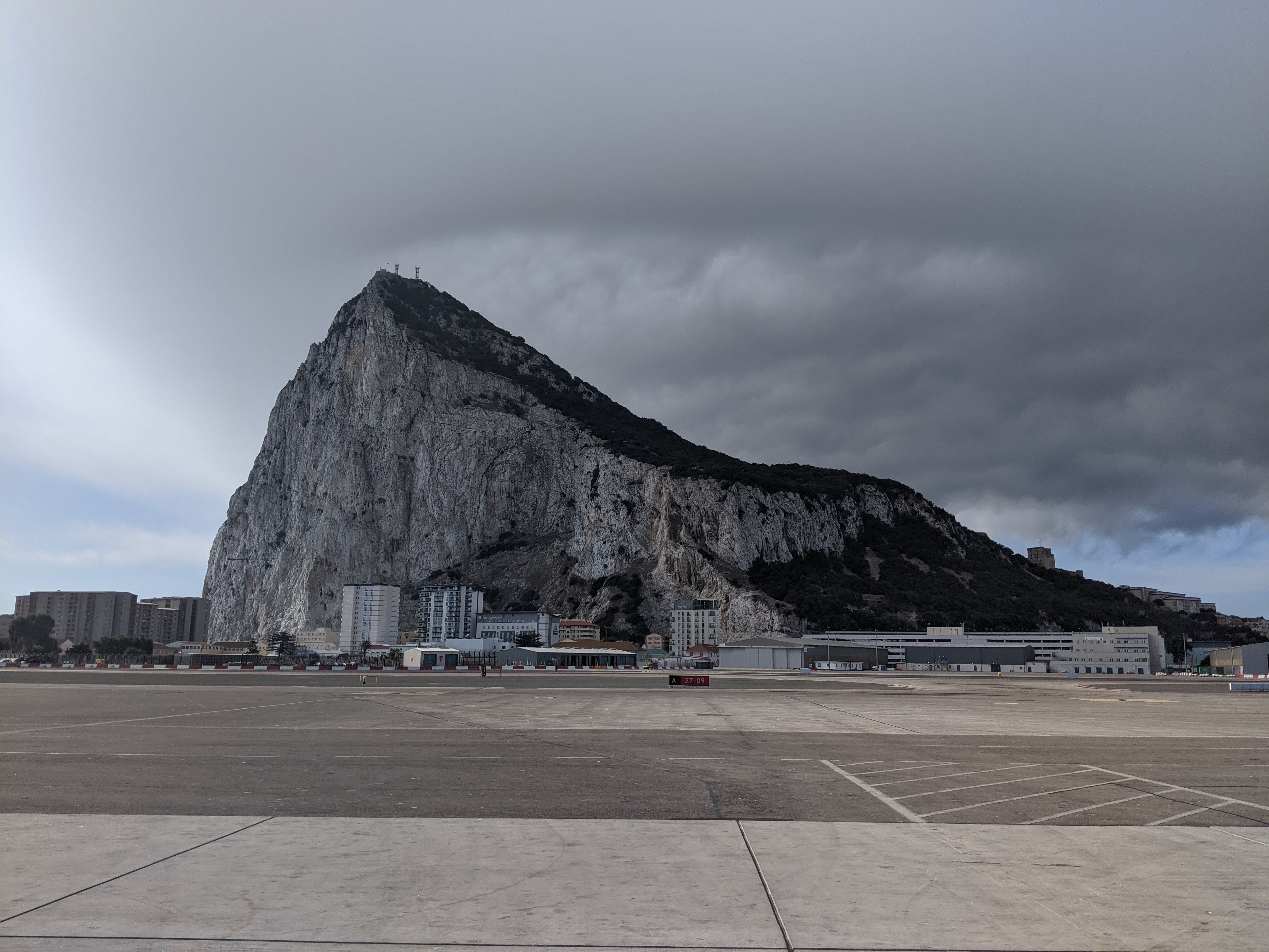
We were at our destination in a matter of minutes (it’s a bit of a surprise just how small this place is). The southern end of Gib shelves down in stages: the high peak of the Rock proper rises from a large plateau called Windmill Hill Flats, bounded by dramatic natural walls that barely need their fortified enhancements (they were sea-cliffs, once, when Gibraltar sat many metres lower in the water). South of it is a second, lower plateau: Europa Flats. Beyond, below another set of cliffs, the sea – and beyond that, a band of steel at the bottom of the aluminium-grey sky, Africa.

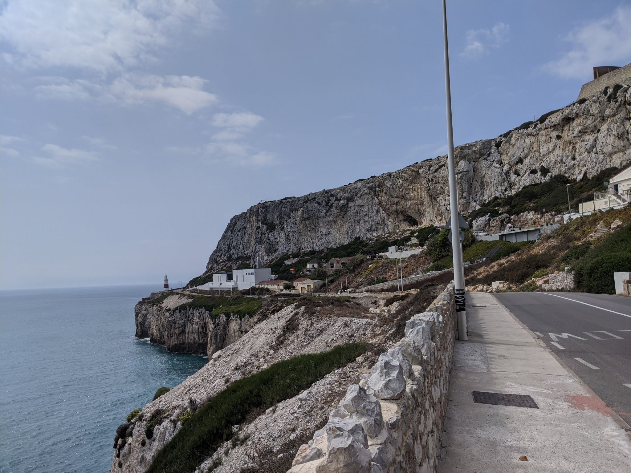
The main road around all Gibraltar skirts the bottom of the Windmill Hill cliffs, and it was there that we got off, near the tall white minaret of the Ibrahim-al-Ibrahim mosque. King Fahd of Saudi Arabia paid for its construction, but apparently not for its maintenance, and it was looking a bit ratty from twenty years of sea breezes.

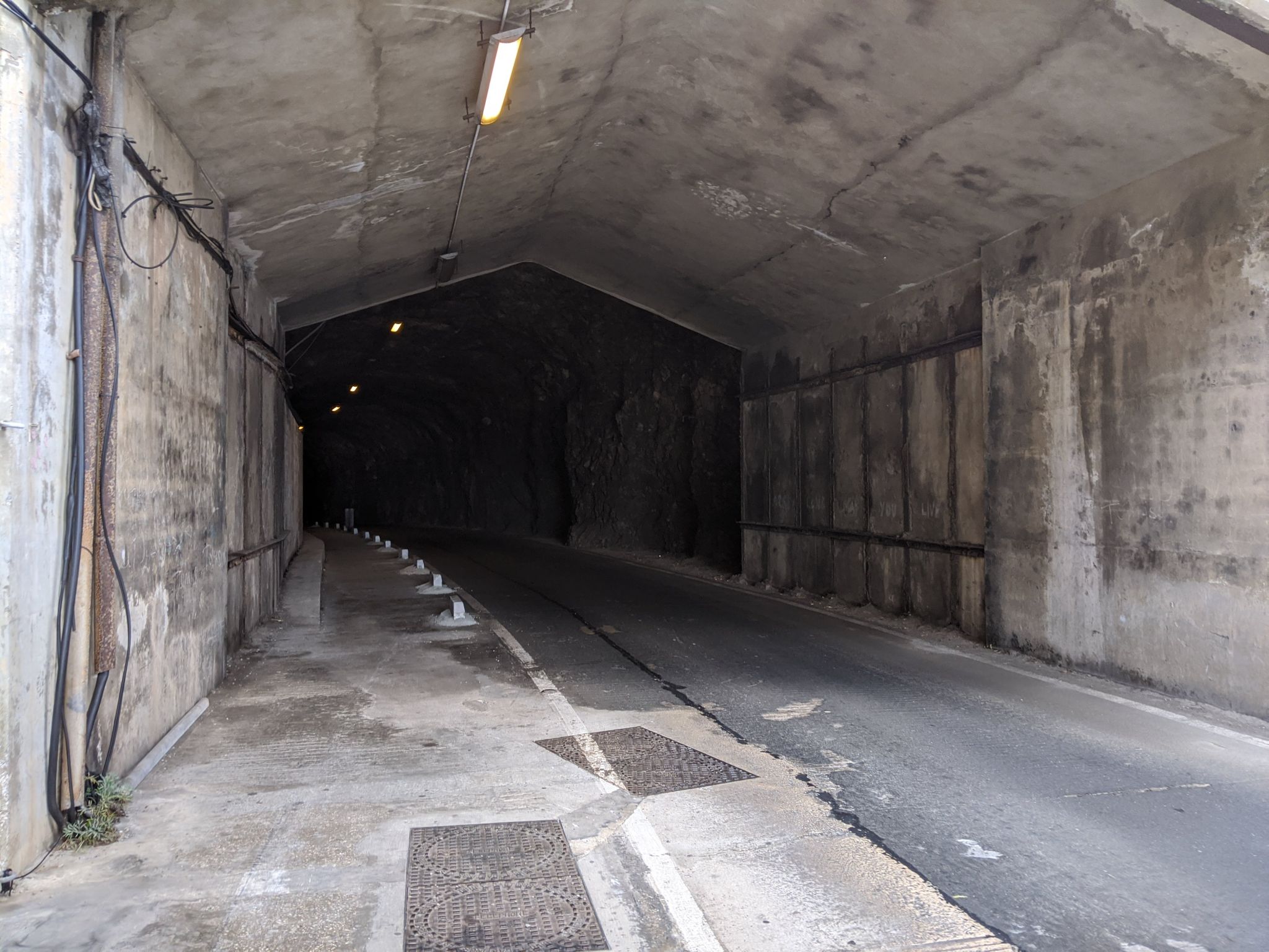
We headed north and east, past the forbidding-looking mouth of the Keightley Way tunnel (which I think is one of the few tunnels there not originally built for a military purpose) and along Europa Advance Road. Above us to the left, the frowning slits of bunkers disguised with local rock; below to the right, the plain concrete backs of yet more fortifications. This quarter of Gibraltar is the most weatherbeaten and least prosperous-seeming part, where the unwanted things go: a crematorium, a rubbish incinerator, a motorbike club. Also, Gorham’s Caves, the UNESCO World Heritage site and possibly last outpost of the Neanderthals.

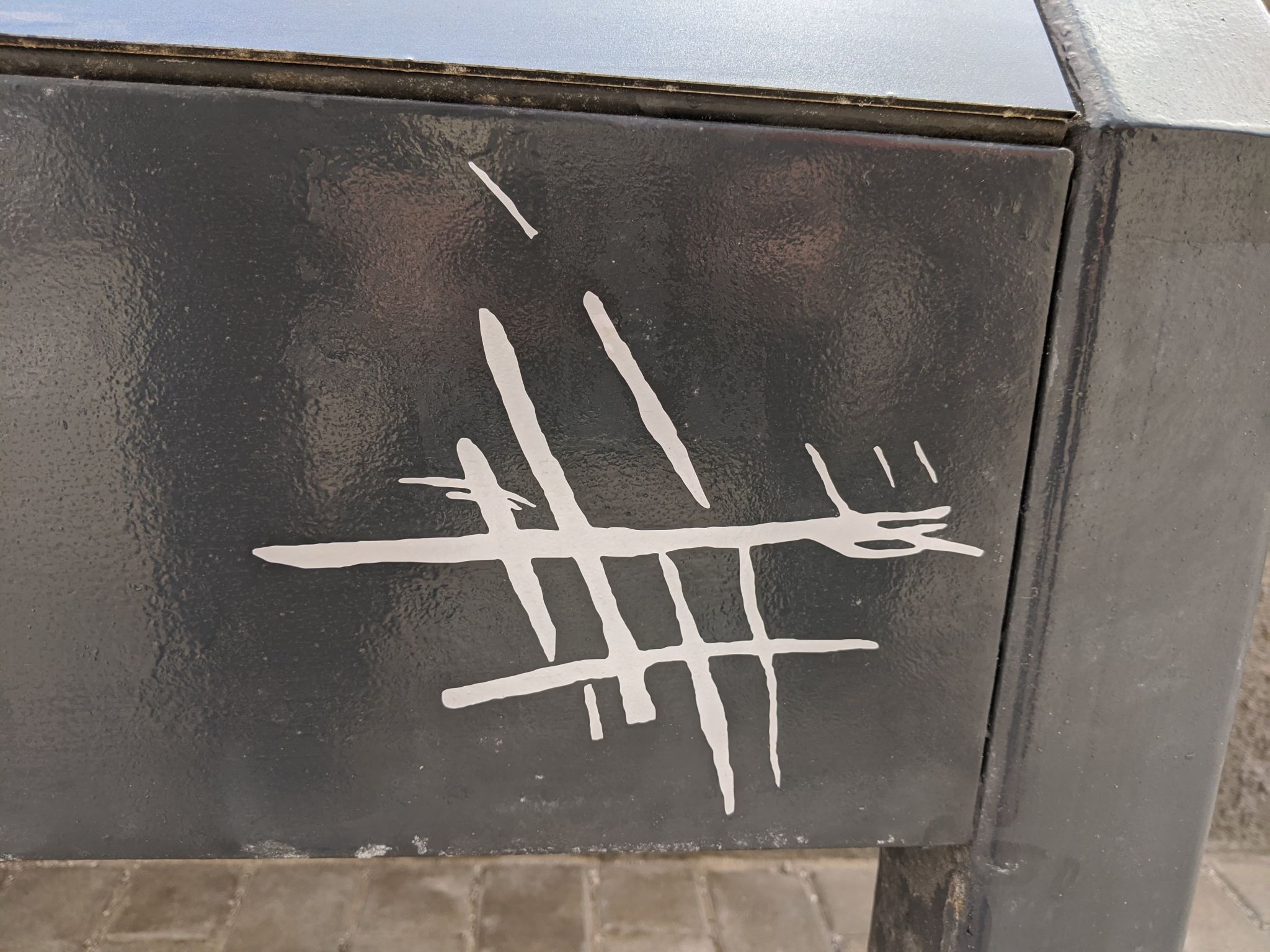
The Caves were included in the joint museum ticket (and would have cost a few quid otherwise), but you don’t actually go in them – the attraction is a viewing platform overlooking the cave mouth with some info boards and a screen. But if you’re lucky, as we were, you also get a fantastically engaging seminar from a local archaeologist, intermittently broken up by pointing out tuna or dolphins splashing around happily in the western Med. We must have listened for an hour, hiding from the sudden midday sun under borrowed parasols, as she vividly described a third limestone shelf (and, beyond it, the swampy, salt-choked bed of Mediterranean for the half-million years between the Messinian salinity crisis and the Zanclean deluge*) gradually shrinking with rising sea levels, concentrating an increasing number of upsetting-sounding predatory animals (that’s where all the big teeth in the museum came from) into a small space around the caves that Neanderthal groups used as home. As well as tens of thousands of years of human leavings, cave excavations have found sustained habitation from our knobbly-browed cousins – most interestingly, the cave boasts a set of forty-thousand-year-old carvings which are argued to be the only known piece of Neanderthal abstract art.

We were invited to offer our own interpretations, but I was at a loss.

Early humans expanding out of Africa came to Spain the long way round, expanding across Europe and gradually wiping out the indigenous Neanderthals (it’s unclear whether through violence or competition for resources, but the result was the same), and southern Spain last of all: the south coast of Gibraltar’s sheer out-of-the-way-ness meant that its little Neanderthal tribe was among the last left on earth.** I thought about the little gnarled people back at the museum, and wondered how much of that they understood before they, too, dwindled away and died.

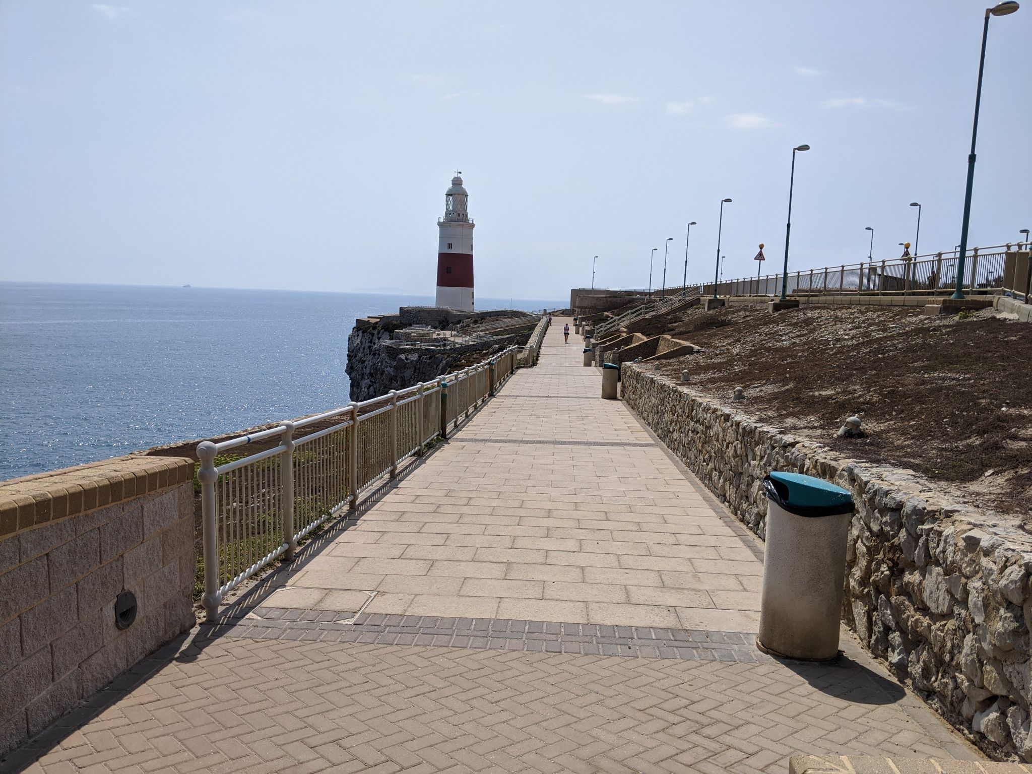
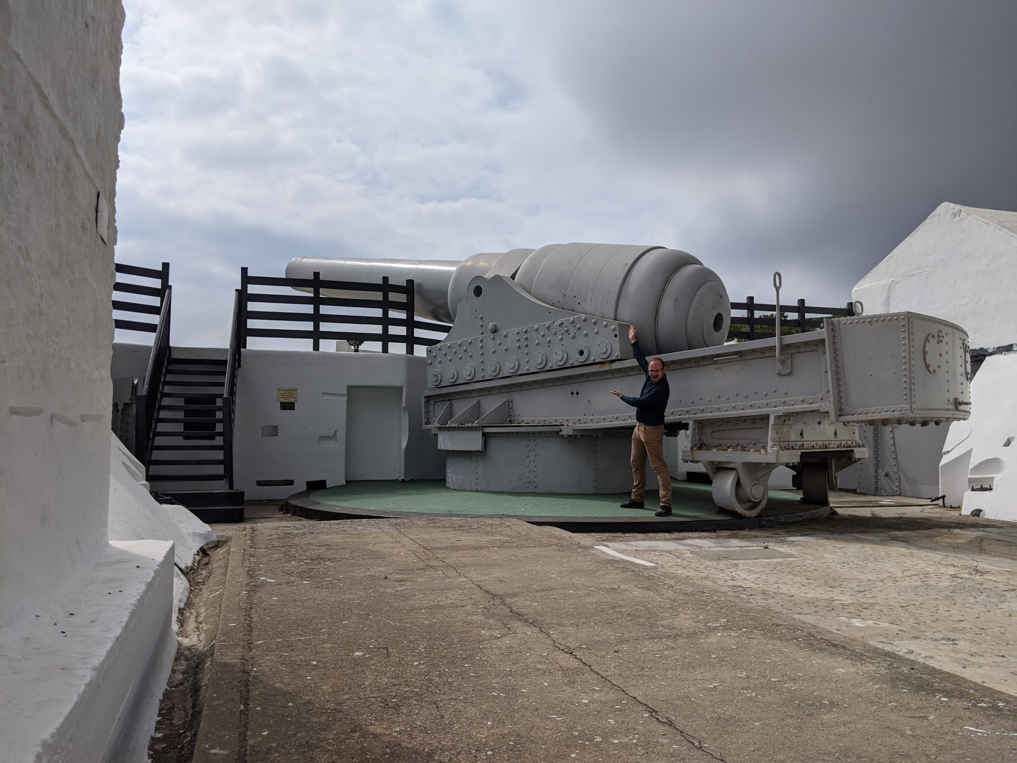
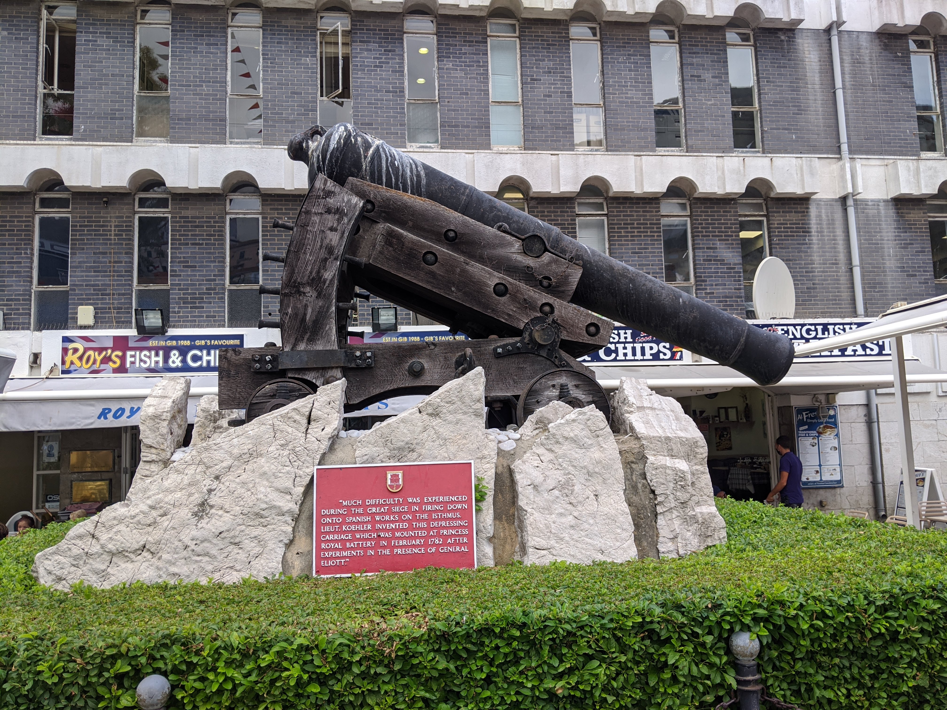
The cloud was clearing on both shores of the Mediterranean, and as we headed south down Europa Promenade to the lighthouse we could see the base of Jebel Musa and most of the Rif Mountains, giant shapes in the haze. It was quiet, and past looking through my telescope at ships (including one that seemed important for work reasons, and the cruise ship Westerdam, lately famous for viral load) there wasn’t a great deal to do. There’s another battery and sunken magazine, with a nicely restored 12.5″ RML (huge in its own right, though a tiddler next to yesterday’s piece), but this one was definitely closed. There’s also a monument to Wladyslaw Sikorsky, leader of the Polish government-in-exile until his plane crashed off Gibraltar in ’43, and its text pulled absolutely no punches about how badly Poland was treated before, during and after the war.

We bussed back into town for a late lunch at the Mad Monk, a wander round the Convent and, finally, another bus trip to the east coast. Our pal at Gorham’s Cave had sadly described the huge dune that’s accreted up on the eastern side as “archaeologically worthless”, thanks to the wartime work to turn the whole place into one big raincatcher (which also extirpated all wildlife, only now just coming back.) It’s still quite a sight.

Overlooking Sandy Bay, beneath the WW2-era ring netting, is a postcard-perfect postwar resort, a great long ziggurat of white-painted concrete, orange tiles and imported Saharan sand (it’s changed a lot recently), contrasting hugely with the rest of the east coast – a gret jumble of derelict bunkers and broken rocks. Nearby, the Admiralty Tunnel cuts through the entire Rock, a tiny glimpse of sunlight visible from the east side.

We dined on swordfish and calamari at Catalan Bay, a pleasing scatter of brightly coloured buildings and mostly-Spanish voices under the great grey shadow of the Rock, and watched the sunset-red ships seem to float above the silver horizon. Then back into town on foot for the last time, past great in-progress earthworks and secure car parks containing enough pickups trucks and 4x4s for another Toyota War, and trying without success to make out all the uncountable loopholes and gun positions peppering the Rock’s northern face.


* Look it up. I’ll wait.
** With the same “as far as we can tell” caveat for anything this long ago. The archaeological record is so patchy that it’s hard to say any of this for certain, but this is the most convincing and widely accepted version.


Gibraltar 2020

Arrival, old town, AlamedaFortifications old and olderAtop the RockMuseums, models and an unfeasibly large gunGorham’s Caves, south and east

one hundred tons of fun

The gigantic gun at the Napier of Magdala battery is, by my standards, the ideal weapon. It’s an exquisitely complex piece of engineering (its smooth fleet-grey paint hides a carefully assembled jigsaw of huge castings; beneath its plain glacis is a warren of magazines and Victorian engineering). It’s a money-no-object application of unlimited resources and cutting-edge technology to a problem (silk bags for its 200kg powder charges! a platinum element for its brand-new electric ignition! its own steam engine and grossly complex hydraulic traverse!) It’s a weird, unique curio, the apotheosis of the rifled muzzle-loader* (a total evolutionary dead end in artillery design). Best of all, it is completely worthless as a weapons system and never actually hurt anyone. The only thing that could make it cooler if it were a part of a huge, sophisticated defence complex rather than just a stand-alone battery. Then I realised: it was, and the complex was called “Gibraltar.”

We started the day with pancakes at the Pancake Factory, and headed to the perfect city museum, which in quite a small space captures everything exciting which has happened in Gibraltar in the last thirty thousand years. Two Neanderthal** skulls have been discovered in Gibraltar, a female adult and a male child, and in an incredibly accomplished scale reconstruction from the skeletons on up, they have been given form as “Nana” and “Flint”; the final result is a pair of engaging, weatherbeaten little people, definitely inhuman but creatures you could probably be friends with. More old-fashioned glass cases held descriptions and preserved pieces of the various terrifying megafauna these poor proto-humans had to share Gibraltar with, before uncontrollable numbers of true Homo sapiens extinguished them all. A similar reconstruction of a modern human, “Calpeia”, sits in a nearby case.

Nana and Flint (photo from https://www.gibmuseum.gi/)

Part of the museum complex is occupied by the wondrous Moorish baths, one of the few non-military survivors of the old Islamic city. Mistaken for a mosque and used as an ordnance clerk’s office in the intervening centuries, it’s an astounding survival, striking both for its similarity to much older Roman designs (in layout, columns, capitals) but also its authentically Moorish flourishes – horseshoe arches, eight-pointed ventilation cutouts. As with the Tower of Homage, half the conservation work seemed to be undoing well-intentioned but disastrous 1970s efforts.

We weren’t meant to take pictures in there, so here’s one from Wikimedia – more here: https://commons.wikimedia.org/wiki/Category:Moorish_Baths,_Gibraltar

The rest of the museum is an interesting assortment of Gibraltar’s best artefacts: Phoenician and Carthaginian relics, a solid-lead Roman anchor, a non-magnetic diver’s knife, a lost-seeming set of samurai armour, a random pickled snake in a bottle, an armband from a German WW1 prisoner – with a GIBRALTAR battle honour his Hanoverian unit earned in the Great Siege. The crowning glory was a gigantic, very precise 1:600 scale model of the entirety of Gibraltar as it was in 1865, with the much smaller Victorian town and its defences – and the immense amount of land that’s been reclaimed since then – very obvious.

We ducked into the local Catholic cathedral, St Mary the Crowned: busy, urban and honestly a bit tatty, its best parts the chipped pseudo-Moorish tiles. We headed south along the old Victorian walls, past Commonwealth Park’s fishponds and an abandoned outpost of Toc H. The dockyard was very reminiscent of parts of the Bristol’s harbourfront – the same hefty Victorian stone buildings and Orthanc-like mega-chimneys, the same modern sheds over huge old graving docks. The key difference was the militarisation – the gun emplacements perched on every mole and breakwater, the firing ports of concrete pillboxes covering all the approach roads – and the vastly larger scale.

The Napier of Magdala battery sits by “Nelson’s Anchorage”, a little semi-artificial cove overlooked by a couple of much older cannon. There was nobody at the door to collect our fee so we just wandered on in, and enjoyed a very well put together exhibition laying out (in English, Spanish and French) the vast, unprecedented High Victorian military silliness of the battery: the three hours it took to build enough hydraulic pressure to rotate the gun, the 23-man crew needed to squeeze a shot out of it every four minutes.**** The RML design meant that the entire 150-tonne gun and carriage assembly had to rotate around to point into one loading port for a giant 15-metre hydraulic ramrod to shove the charge in, then twirl a full 180° to the other port to take a shell, then be laid on target. (Like the Duilio-class, it also meant that during the loading sequence the battery had a fully loaded super-heavy gun pointed at its own magazines.)

This absurdly involved loading process is the reason it was such a useless weapon – the gigantic 900kg shells it fired were well beyond overkill on any ship of the day, but meant the rate of fire was hopeless and the chance of scoring a hit on anything faster moving than an island minimal. The Royal Navy knew this initially, and turned them down when Armstrong initially offered them – but when the Italians eagerly snapped some up for their new battleships and started making threatening noises about Malta, the British government suddenly felt outgunned and bought a bunch with the 1870s version of an Urgent Operational Requirement (sadly, designs for a 224-ton gun never came to anything). So these ludicrous dinosaurs proliferated all over the Mediterranean, Armstrong built Cragside, and nobody was hurt.

“The day before practice firings of the gun, the Gibraltar Chronicle warned people to leave their windows open and take fragile objects down from shelves.” As we left, we noticed the gate had been closed; possibly the whole exhibition should have been. Whoops?

Having ticked off the day’s to-do list, we went into General Exploration mode. An amble uphill along a broad stairway took us to the old naval hospital (now St Joseph’s School, much brighter than its 1/600-scale 1865 representation, but very recognisable); we were getting thirsty, but weren’t convinced by a grotty-looking pub called “Wembley”. St Joseph’s church, built for the Maltese community, had an almost Greek-looking tower, an interestingly broad, sweeping arch to its ceiling, and a psychedelically bright mural above the altar; past it, the tower blocks south of the Alameda had the feeling of a London council estate on a muggy day.

We descended to the old town for a siesta and a surprisingly good Indian-Japanese fusion dinner, then had a good night wander of the quiet streets and the northern defences. The levanter had given the Rock a dramatic quiff of cloud, lit from beneath by the airport floodlights, and the Tower of Homage sat on the city’s shoulder like a cube of rose gold.


* ARTILLERY ESSAY TIME! Early 19th century guns of all sizes were basically smooth iron tubes, open at one end, into which you put a charge of black powder and then a ball. Breech-loading (putting the shell in at the back) is an improvement for various reasons, including working better with rifling, but mid-C19 technology had difficulties making a breech which opened but was strong enough to contain a large blackpowder charge. Thus, RMLs – rifled muzzle-loaders, which look very silly now but for several decades were the acme of heavy weapons.*** Eventually, improvements in metallurgy (better steel castings), chemistry (nitrocellulose guncotton and later smokeless propellant, which burned more controllably than blackpowder) and engineering (threaded obturation seals which would “screw in” and securely hold a breech closed) enabled the creation of modern artillery, which hasn’t changed much in over a century.
** Gibraltar 1 – “Nana” – was actually found before the Neander Valley skull (though after Engis 2 in Belgium), but initially misidentified as human. If her finders had known what they were looking at, the knobby-browed prototype humans might have been called Gibraltarians rather than Neanderthals. Hmm.
*** They aren’t even close to the weirdest late-19th century naval weapon in an era which also saw spar torpedoes and ironclad ram ships. My favourite entirely forgotten, now utterly bizarre-seeming 19th century artillery experiment was the “dynamite gun“, basically a pipe using compressed air to throw bombs made of dynamite – which couldn’t be safely fired from normal guns without setting it off.
**** One enterprising commander, Lt. Col Ogilvie, got this down to two and a half minutes – “which possibly contributed to the splitting of the original barrel.”


Gibraltar 2020

Arrival, old town, AlamedaFortifications old and olderAtop the RockMuseums, models and an unfeasibly large gunGorham’s Caves, south and east

no es mi circo, no son mis monos

Gibraltar continued to flex its Britishness by being cloudy and grey for our second day of Rock climbing. Despite being plausibly walkable from one end to the other in about an hour, there is a regular and well-run bus system, and as we headed to the cable car stop a #4 passed with BOTH WORLDS on the front and “Possibilities in every direction” on its side, the two between them promising a strange Gibraltarian existential limbo. The cable car station has numerous warnings, best of all a series of comics, about the various cunning ways the Barbary macaques (technically not apes but everyone calls them that) exploit distracted tourists to steal snacks.

The cable car itself is just modern and functional, without the powerful scents or maintenance-related terrors of Chiatura, and it goes right up the Rock very quickly. The Bay of Gibraltar was scattered with ships; a string of enormous container vessels and bulk carriers in ballast were moored beyond the mole, each paired with a little blue oiler, like some odd highly-dimorphic creatures mating. The top station is part of a big, grey, windswept concrete complex covered in monkeys and monkey shit, with a restaurant we didn’t need and a platform with some talking telescopes. At the western edge, the levanter strikes the Rock and creates a powerful shearing updraught, on which big birds of prey with pale bars along their backs and upper wings soar. It blows the scrubby trees and bushes into weird shapes, and combined with the grey light gave a haunted, wintry Dear Esther feeling to the old stone, crumbling wartime concrete and new stainless steel of the buildings on the ridge.
Immediately after leaving the complex, we got a salutary lesson in monkey business when a mother ape (with tiny baby on her back!) leapt onto a fellow tourist’s backpack, opened it up and yanked out a couple of (cereal? chocolate?) bars, then ran off as he plaintively asked for them back. Thereafter, all rockapes were regarded with maximum caution, and any rustle from the undergrowth attracted suspicious glances and hisses of “Charlie’s in the trees”. Along the ridge line, keeping a very close eye on the monkeys (which pad gently around after you and insouciantly glance away if they notice you making eye contact) we encountered the “Skywalk”, one of those glass-floor-in-high-places things designed to induce vertigo. The view through the bottom wasn’t great (grips sensibly cut into the glass also make it quite hazy), but up top a replica Bofors gun mount had plaques showing the distances to various parts of the ex-empire and another commemorating the opening of the “Skywalk” by the chief minister and… Mark Hamill. The forces of dorkness are never far away. As we continued, past the monkeyproof bins, other rockapes leapt onto a passing tourist minivan and banged on the windows; the driver got out to remonstrate with them, but they couldn’t be reasoned with.
The next stage of our walk was in fact steeply downhill; down steps, mostly, along the top of the walls of Charles V* – a curtain wall that blocks off the upper Rock between two basically-impassable cliff areas. We really did wonder about this: it’s a shockingly expensive piece of engineering, but too high and too far from the town to be closely defended, and even for the mid-16th century too light to stop a serious assault. Later, we worked out it wasn’t for dealing with seriously well-armed hostile forces but for the Barbary pirates – like Hadrian’s Wall or the Great Wall of China,  more of a sort of military Serious Callers Only filter than a fighting position. We descended the stone staircase, having to lean awkardly past an obstructive monkey with a prominent erection.

We followed a track along the west face past the footings of more gun batteries and searchlight positions, heavy old pipes of water catchment infrastructure, the elegant but utterly pointless Windsor Bridge. There were few monkeys, but plentiful, er, evidence of their habitation, and every so often a bricked or gated archway led into the Rock (and presumably directly into the tunnel system.) Across the bay, the haze had lifted enough to clearly see Algeciras, if not Morocco. We clearly heard and saw an RAF Atlas transport come down – the first time I’ve seen one in action.

By this point in the day we were more than a little hot and thirsty, so it was fortunate our next stop featured both a freshwater tap and a huge cold limestone cavern. St Michael’s Cave was simultaneously the most physically impressive and least emotionally engaging hole in the ground I’ve ever been in. The limestone formations are some of the coolest I’ve ever seen, all frozen curtains and stacks of petrified broccoli; but the place has been hacked about from field hospital to concert venue, the air smells of despair and monkey piss, and they play shit-tier tepid club music and flash lurid colour-changing lights which quite rob the place of any atmosphere. One of the info boards noted a legend that the cave led to a tunnel that ran all the way under the Straits to Africa; the thought of that, and of walking miles and miles beneath the sea in dripping darkness, is the only part of the system which still retains any power.** In the site office, next to a closed souvenir shop, a phone rang forever.

Refreshed and cooled we headed up to the Spur Battery, a great ring of Edwardian concrete which once served as the barbette for a 9.2″ gun and still commands a magnificent view of the southern tip of Gibraltar. In the magazines below, I half-saw an assembly of old equipment by the light of a smartphone’s flash. Then (and that “then” encompasses about half an hour of climbing steep road in blazing heat) we made it to the very peak of the Rock, O’Hara’s Battery. O’Hara was a Regency-era Governor of Gibraltar known for surrendering both Yorktown to George Washington (little known fact: Cornwallis was in command but claimed he had a tummyache and sent O’Hara to actually surrender) and Toulon to a dashing young Revolutionary captain called Napoleon Bonaparte.

The question of whether Mr O’Hara was a complete cretin – it’s perfectly possible, after all, to lose to two of history’s great captains while still being fairly bright – is swiftly answered by learning that once given command of Gibraltar he a) decided that adding a few metres of height to the Rock by building a tower at its peak would let him see clearly into the harbour of Cadiz (100km away and behind a mountain range), b) he funded it out of his own pocket c) he had the stone iron-fastened, virtually guaranteeing the lightning strike that destroyed the tower almost immediately after its completion. After that it gets more complicated; the infographic tells an attractive story about HMS Wasp knocking the sundered remains of “O’Hara’s Folly” down with a shot from the harbour in 1888, but the last HMS Wasp foundered off Singapore in 1887, so who knows?

Regardless: below, it’s a magnificently preserved set of generators and magazine equipment, generators and shell hoists, all whitewash, green paint and polished brass with attendant mannequins in khaki battledress. Above, it’s a huge grey boxy housing for a 9.2″ gun easily capable of wasting anything in the port of Algeciras and able to at least frighten anything crossing the Straits on a clear day; two more, at the nearby Lord Airey’s Battery and the distant Breakneck Battery, are the last survivors of the fourteen Mark X guns Gib once boasted. We stayed there a good long while, boatspotting with my telescope and marinetraffic.com.

To get back down to the base of the Rock we took, the Mediterranean Steps, which are about as close as I’m (willingly) going to get to Cirith Ungol: a very steep, very rocky, very rugged descent into shadow towards the sea. A surprising number of clearly very fit locals came up the other way as we descended, and we were bemused by the flotilla of little boats chasing little splashes in the immense shadow of the Rock until we realised they were dolphin-watchers.

At the base – past caves ancient and modern, a derelict pumping station and dozens of abandoned observation and fighting positions – we found one final empty 9.2″ emplacement, now the home to a fun but irredeemably tacky monument to the Pillars of Hercules. We made a quiet visit to Jew’s Gate Cemetery, utterly peaceful in the lee of the rock with its spiderweb of elevated walkways carrying visitors above its rows of bone-white tombstones. And then it was time for the bus – just one way – back into town.


* That’s Charles V the 16th century Holy Roman Emperor – not the 14th century Charles V of France, nor the 17th century Charles V of Naples, nor the failed 18th century pretender Charles V of Spain. Charles V of Sweden never actually existed and starting the line at IX was a fiction by the House of Vasa to give themselves more of a pedigree. Dynastic history is bonkers.

** Honestly, it makes me want to read Journey to the Centre of the Earth all over again.


Gibraltar 2020

Arrival, old town, AlamedaFortifications old and olderAtop the RockMuseums, models and an unfeasibly large gunGorham’s Caves, south and east

A History of the Rock in 14½ Sieges

The first full day started with a powerfully protein-heavy breakfast at a joint called the Pancake Factory, which does big hearty meals, big hearty piles of pancakes, and proper coffee for really not much money. We needed the fuel, because from the town the only way was up. Striking out east, we ascended a long, winding staircase, littered with cats and with the odd mural adding a splash of interest to the pastel-painted buildings: Andalucian peasants, a two-storey octopus. For a peninsula bounded on three sides by water, it’s honestly astonishingly hard to actually see the sea from anywhere in built-up Gibraltar, even a long way above sea level. Eventually, we reached the Moorish Castle, or the Tower of Homage (I’m still not sure why it’s called that).

All the attractions on the upper Rock have a shared ticket, with a festival-esque wristband bearing a QR code you scan in at turnstiles. The usual covid facemask’n’Purell measures already feel like they’ve been there forever. On the outside, the Tower of Homage is a formidable-looking block, heavily pock-marked by both catapults and cannon. On the inside it’s a surprisingly elegant building as castle keeps go, built in a Romanesque style of thin red bricks separated by thick bands of mortar, and highly sophisticated cement vaulting well ahead of anything in northern Europe at the time (the Rock itself would of course have provided lime for unlimited cement). Those lovely Moorish eight-pointed stars made a showing in the ventilation cutouts above a bath area, and at the centre of decorative plasterwork ribs on the domed ceiling of a tiny interior chapel. The present, strikingly bare, state of the walls and brickwork is both recent and deliberate; it’s all basically undoing a 1970s “restoration” involving slapping concrete and quarry tiles everywhere then adding “Moorish stuff”, which from pictures in the museum made it all look like a budget shisha bar.

From the top of the keep, still in its 1970s form with lots of spiky, historically-off but quite stylish merlons (the restoration probably ran out of money a storey down), you can see clearly the line of the old Moorish walls running down on two parts to protect the oldest part of town, and a sign of how much the town has ballooned out (with WW2-era searchlight positions to watch La Linea perched on some of the ancient towers). From it and the garden below, you can also clearly see the airport, and we watched an easyJet come in from near the position’s mandatory 24-pounder, and sat a peaceful few minutes watching the frogs and terrapins in the pond before moving on up. A delicious cool musty breeze came from the mouth of the WW2 tunnels, but the next tour wasn’t for over an hour, so we pushed on up the slope, past our first Barbary macaque (fluffy, aloof), concrete rainwater cisterns and a section of the fantastically fate-tempting “Unclimbable Fence”, complete with mocking info board. The next exhibition, Willis’s Magazines, built around a couple of gorgeously built powder magazines (with very solid looking walls and, in a way which dates it, very solid roofs**), presented the story of the Great Siege with info boards and a selection of quite well-made mannequins having various types of bad time.

Up another zigzag was a closed Military Heritage Centre, some mucked-about-with old gun emplacements with a set of flags, and a plaque commemorating a visit in 1954 by Brenda and Philip (yawn!); but down a neglected looking side passage we found a marvellous battery of four 5.25” dual-purpose*** guns in boxy turrets that look like they’d been yanked directly off the deck of a destroyer (and may have been). Watching the booted eagles twirling above the cemeteries of the shady northeastern quarter (Christian graves divided from Jewish by a white wall, men from women within the Jewish cemetery by a green path) we got our first taste of the easterly wind blowing out of the Med towards the Atlantic; elbows against the railing, we could feel it singing.

At the entrance designated “WW2 Tunnels” you scan your wristband, are issued a helmet and an audioguide, and follow the polite young Spanish chap into miles upon miles of dark, damp, musty WW2 excavation. The objects left behind (a terribly rusty 25-pounder gun-howitzer, a filthy old Lee-Enfield rifle, a panoply of 1940s rock-drilling equipment) aren’t that impressive, but the photographs, maps and general historical storytelling are excellent – the tragic tale of the 13,000 Gibraltarians evacuated to Casablanca only to be kicked out by the vengeful French after Mers-el-Kibir being one standout, the unbelievable Operation Tracer another, and photos of Gibraltar celebrating Italy’s surrender by lighting off every searchlight and gun on the entire Rock simultaneously a third.

But the real stars are the tunnels, coupled with the knowledge that they are just the tiniest fraction of the unbelievable amount of subterranean fortification on this level alone, with more layers above and below. The fortress was designed to hold sixteen thousand men, with food and ammunition to fight a major siege. A whole underground city was built: huge galleries hacked and blasted from the limestone, Nissen huts installed inside them to reduce the effects of the upsetting caveyness (and moisture) on the troops, vast underground reservoirs built for rainwater. The audioguides made a weird cacophany off the wet limestone walls.  Each segment has a British place name: Fosse Way, Maida Vale, Peterborough Chambers – pleasingly, the biggest confluence of different tunnels was called Clapham Junction. At “Jock’s Balcony”, one of the hundreds of positions for observing (or shooting at) anyone trying to cross the isthmus from Spain, we staggered out into the blinding sunlight and tried not to imagine what it would like to cross all that under fire from modern weapons.

Back up the hill we encountered an entrance to the Grand Siege Tunnels, a set of 18th century fortifications beefed up by several subsequent garrisons but all working on the basic principle of a tunnel through the Rock with a bunch of gun emplacements poking out the side. The Gibraltar heritage community clearly has both a lot of love and sufficient money in it, and told a thorough, compelling story of the Great Siege, the downwards-firing gun carriages developed for the unusual use case of firing a cannon straight down a cliff face, and the subsequent higher-budget Victorian takes on the same. At the end of the older stuff is the “Notch”, a fantastic rock promontory which creates a natural bastion firing in all directions; a later set of WW2 tunnels cut down sharper and steeper, creating further gun positions through less well-made tunnels, including one which cuts straight through the Rock to an exceptionally weatherbeaten mortar crew of mannequins peeling in the endless easterly wind.

It was already 16:30 and we had barely left the northernmost edge of the Rock, so rather than burn ourselves out we worked out the quickest and gentlest descent back to town. This being Gibraltar, even that path took us through three different heavy weapons positions: the Tovey Battery, an empty pair of open 6″ positions; the Genoa Battery, an ancient Spanish position overlaid with WW2 concrete and searchlights; and last but best, the Devil’s Gap Battery, an Edwardian fortification with a handsome pair of 6″ guns and an unusually well-preserved set of shell hoists and gear in the battery underneath them. Dodging the occasional car of Gibraltar’s high-level one-way-system, passing a cactus garden on one side, we descended into town, and found a marvellous tapas place called Hacienda Patagónica for some really rather good meat, cheese and wine. A strong first day of Rock-climbing, we felt.


* With apologies to Julian Barnes. Sort of.

** Modern structures designed to contain stuff that goes bang are designed to allow a potential bang to be able to escape in a harmless direction. This is typically achieved with very solid walls and a very light roof. Trying to contain a bang generally creates a bigger bang – more of a problem for modern high explosive than gunpowder.

*** Which is to say, for shooting at both air and surface targets. The purpose is, ultimately, to kill people.

Gibraltar 2020

Arrival, old town, AlamedaFortifications old and olderAtop the RockMuseums, models and an unfeasibly large gunGorham’s Caves, south and east

it is Rock o’clock

Click the images for full-resolution versions less horribly compressed by WordPress!

We arrived at Gibraltar thirty minutes ahead of schedule, a long, languid descent watching our plane’s shadow wander across the desert-camo bedspread of Andalucía: towns scattered like patches of powdered chalk, solar farms glittering like golden medals. The pilot made a long, full circle of the Rock for our benefit; where most of Spain had been cloudless, it sat glowering underneath a hazy hat of stratus, as if asserting its authenticity as a piece of Britain-outre-mer through sheer defiant overcast.

The Gib-side border post at La Línea de la Concepción flies the flags of the UK, Gibraltar, and a circular gold design against a dark blue background: the Commonwealth of Nations. The road to Spain is also the airport’s runway, and we walked across the huge, humid emptiness towards the immense face of the Rock, freckled with foliage and firing ports, its silhouette broken by the signals base at its peak and the looming lump of the Moorish castle at its hip.

The little details of Gibraltar jump at random between extremely British, thoroughly Continental, and uniquely local. People drive on the right in the sort of vehicles you expect in Spain, but stop at the exact same traffic lights with the exact same buttons as back home. Telephone boxes are the Gilbert Scott classics; postboxes are the same design as at home but have black hats and details; buses are red, but a dark oxblood rather than London Transport scarlet; the tower blocks in the northern district have the same sort of names and lettering as postwar council estates back home, but paint jobs, AC and serious shutters appropriate for the south side of Spain. A war memorial commemorates “THOSE WHO DIED FOR THE EMPIRE.” It’s charming but uncanny, like wearing cultural bifocals that keep slipping in the humidity.  We advanced up the main drag, observing British shopfronts and Spanish pavement habits, to our Airbnb on a side lane just past some government buildings and giant Playmobil figures. We assumed the immense numbers of Gib flags, Union flags and red and white bunting overhead were artefacts of Gibraltar Day (the day before we arrived) rather than an Orange Order-style statement.

We stopped at Casemates Square for a full English (perfectly authentic, though no more than decent; sachets of British vinegar and Spanish mayo, and coins the same shape and metal as back home but minted with different designs). On the docks, we found the crown jewel of the Morrisons empire: shining white, glossy and modern on the outside, with shades above parking spaces to protect against the Mediterranean sun. Inside, it was almost exactly like the one in Burton on Trent. Weird.

“It’s not THAT depressing. I think it’s rather clever, actually.”

Looking at a map, two things very clearly define the geography of the town: first, the difference between the “old town” of dense alleys (mostly Regency or Victorian, mostly rebuilt after the devastating siege of the late 18th century) and the “new town” of high-rise estates built on land reclaimed from the harbour. Second, the immense bands of defensive architecture between the two: Victorian battery upon Georgian bastion upon Spanish star fort upon Moorish curtain wall. Casemates Square, the main town plaza, is named for the rows of vaulted artillery positions that line it; it even has an iconic depressing gun with a helpful plaque (which, sadly didn’t explain how they stopped the ball from rolling out. Lots of wadding and a couple of prayers, I expect).

It’s almost impossible to look anywhere in Gibraltar without bumping into some sort of fortification (at one point I literally glanced into a flowerbed and found a plaque explaining that hello, this was once the Devil’s Tongue Battery) which makes it more or less My Perfect City. Huge old 32-pdr batteries perch above street corners; Armstrong 12” RMLs, rare in the UK thanks to their substantial scrap value, just sit in the street with nice new coats of paint; most of the bollards in the city seem to be honeycombed old cannon (including, a rarity in the role, carronades!) Much of the old defensive layout is obscured by Gibraltar’s sheer City-of-London density, but the walls, bastions and batteries are all still there, some turned over to moped parking or rooftop restaurants, some to linear public parks. The latter parts are scattered with war trophies (lots of captured Russian cannon from the Crimea) and monuments to the fallen of various nations in various wars: everything from quiet stone plaques to a massive American triumphal gate with two giant gold dishes stamped with big eagles.

“I’m Queen Victoria, and this is my favourite part of the citadel.”

From the King’s Bastion, we saw an understated Star of David on a wall picking out the Nefutsot Yehudah synagogue; a little beyond it was the rather more extroverted Cathedral of the Holy Trinity, an Anglican affair which from the outside looks like a Moorish leisure centre done up in Russian-style bright pastels. Inside, it has the lovely, sunlit, airy feel of a good 18th century church, except that every single architectural detail is wrong. The utterly banal God-pop music playing in the chapel of St George gave it a fairground feel quite at odds with the serious historical substance and the memorials and mementos lining the walls.

Beyond it, past the town’s Southport gate (possibly the only building anywhere bearing the arms of both Queen Victoria and Charles V, Holy Roman Emperor, plus a natty pair of Pillars of Hercules*) was the Trafalgar Graveyard. An assortment of mostly-Napoleonic war graves, many with cannonballs or mortar bombs perched on top of them, its mournfulness was no way offset by the loud parakeets or the huge monarch butterflies flapping and gliding around, and it felt a clear and worthy antecedent to the Victorian obsession with baroque, industrial-scale cemeteries. (The info boards play up the presence of Trafalgar casualties, but skate past the obvious fact that those killed outright in the battle would have been buried at sea; the Trafalgar dead buried here are those who died of their injuries some time after the battle, having made it back to Gibraltar while suffering horribly from mortal wounds. I suppose I can see why they don’t dwell on that.)

Thinking ahead for the next few days, we scoped the cable car station up to the top of the Rock (a constant looming presence whenever we glanced to the east, its cloud-cap continually drifting out to Algeciras and dissipating above the bay) and in doing so stumbled across the Alameda, or the Botanical Gardens. The Gardens were charming, well-kept and, like everything else in Gibraltar, full of artillery. Ranges of interesting cacti and succulents, more 12-inch RMLs, tinkling fountains and babbling artificial brooks in shady artificial groves, 18th century bronze howitzers, a great big bronze dragonfly perched by a pond, a Wellington monument with some dinged-up mortars, an Australian set so perfectly authentic a whiff of gum-tree made me think unbidden of kookaburras and shiver.

* Plus ultra.


Gibraltar 2020

Arrival, old town, AlamedaFortifications old and olderAtop the RockMuseums, models and an unfeasibly large gunGorham’s Caves, south and east

there’s a world going on underground


My godparents’ place near Cunault, on the south bank of the Loire, has a maze of artificial caves underneath it, the remains of an old limestone quarry. These are very common in the area – the lovely white limestone manoirs and chateaux here were built from the stone directly underneath them, and stone was also exported up and down the river to nearby towns.

This one in particular we think is mostly 19th and 20th century, although some of the evidence we found might go back to the 1780s. Some of the local caves were used by resistance fighters as hideouts, but we’ve got no reason to believe this one was. After the war, it was used to grow mushrooms (using manure from the nearby cavalry school at Saumur) until cheap Polish imports rendered that uncompetitive. A group from a bat conservation society did a pass some time ago but didn’t record the actual layout. So that was my project.

Methodology – I looked at various cave-mapping resources designed to make incredibly detailed maps (many in three dimensions.) and felt them overkill. Instead I used a very simple approach:

  • At each junction, write down and place a piece of paper giving the number of the junction and the direction you’ve come from, to always have a pointer home.
  • Take the left-hand passage.
  • Count steps until the next junction and repeat from 1).
  • If you reach a dead end, retrace back to the last junction and take the next from.

I would end up with a topographical map (more like the London Underground) rather than a perfectly accurate one, but that’s basically what we needed.

Equipment: Being alone and not particularly wanting to die in pitch blackness, I had a pencil torch, a headlamp for reading the map, my phone torch as a backup and a hand-crankable torch as a backup backup. We improvised a clipboard from a piece of hardboard and two bulldog clips, and I took a crayon to mark junction sheets and a biro to draw the map. For my first expedition, I wore a jumper and jacket and carried a bag with food and a water bottle. This was totally surplus to requirements, the cave being a fixed temperature with still air, and I did the rest in my shirtsleeves!

Expedition I

Explored up to Junction 14. Got a general sense of the journey as a wide sweeping semicircle, with a lot of dead-end shafts about 25m long on the eastern (?) side, including one full of salty mud. Reached a vent to the surface – think it’s the one on J&S’s land but not sure; there was an actual hump on the ground of fallen dust and dead oak leaves. Some interesting graffiti and tally marks with pre-WW1 dates; some little clear pools of water, one area north of the vent where water’s dripped out of the ceiling and made lots of tiny holes in the floor. Otherwise mostly dry, wide passages, mostly tall enough for me to stand up in. It didn’t actually feel too oppressive alone in the dark down there, but gosh I’ve never seen as warm and wonderful a sun as when I emerged.


Expedition Ia

Went up to the vent in the hill above the house and tossed a log marked with green paint down to make sure it was the same vent. (Turns out it was!)


Expedition II

Found the green log at J13 and proceeded on to J26 including through some quite cramped, difficult tunnels. Found a tally from the bat people and determined that there is indeed a complete circle underground. Most interestingly, went down a long side passage at J21 and found – as well as a lot of fun graffiti and some carved crucifixes – a portrait of a gent with a pipe.

Expedition III

Mapped the full outer circle properly (J27-29) and discovered on returning to the J3 turnoff there is another large internal circle (J30-42). Previously placed markers had gone a bit soggy in the ambient humidity. Near a couple were some of millipedes, a couple of inches long and the same light tan as the earth – the only sign of life down there. We may need a more durable form of junction marker. Found a bunch of mounds of earth which I assume are for growing mushrooms rather than being the last resting place of various Maine-et-Loire mafia hits. Not digging into them to find out.

Expedition IV

Expecting mainly to deal with the dead ends at J10, J19, J26, J28 and J30, almost all places I looked at and went “nope” to on previous expeditions. As it turned out they were mostly fairly simple, with one very cool passage past J46 where hundreds of tiny stalactites had formed and dripped glittering crystal over the rocks beneath them (first video on this post). Took a closer look at the pile of stuff off J27 – looks like infill from above (wonder where?) with some tiles on the side of the chamber which are very plausibly asbestos. As long as I don’t rub my face onto it I should be OK, right? Emerged into the light to consolidate my notes at length with cheese and wine.

The final result of my efforts. Click the image for a Remotely Legible version.

I’ll leave it to my godparents (who are architects and can actually hold a pen) to reduce this into a useful format, and they’re talking about putting down little ceramic tiles as junction markers. We will, in the end, need 46 of them…

Chernoblog Roundup Post

Since the recent HBO Chernobyl show appeared I’ve had a lot more interest in my travelogues from visiting the Zone of Alienation back in the spring of 2015. I posted these “live” to a tag, which makes them a bit awkward to read sequentially. So, to help anyone I’m linking this to, a combined post. Enjoy…

Part 1 – the journey from Kyiv to the Zone, visiting the Chernobyl Nuclear Power Plant itself, the construction site for the New Safe Confinement (then incomplete) and the unfinished cooling towers for Reactor V.
Part 2 – exploring the dead city of Pripyat, with highlights including the Palace of Culture, Hotel Polissiya, the famous amusement park, a shopping precinct and residential tower. We then stayed the night in the town of Chernobyl itself.
Part 3 – the next morning, visiting the site of the Duga-2 “Steel Yard” receiver array and the Pripyat hospital.
Part 4 – sites in Pripyat: cafes, a school, swimming pool, post office, fire station, and the monuments and leftovers in the town of Chernobyl itself.

the hall of the mountain queen

This is the last post in a series! You can start from the beginning in Kutaisi here, or browse the whole Adventure in reverse order using the tag here. And as ever, click the images for full-size versions.

The 12th century Tsunda church: locked to visitors, with an alcove by its hearth stained with the soot of centuries of votive candles.

Breakfast was a truly scrumptious mix of local fruits, veg and preserves, cheeses, fresh bread, and good black tea (with milk, even!) Unfortunately Arpi was still Very Sick and couldn’t eat, so half – well, a third – of it went back uneaten. I scrubbed the transport arrangements to Batumi, cancelled the nice-looking airbnb there, agreed another night with our lovely hosts, and asked them if the offer to drive me around the ancient monastery and fortress complexes was still open. It was. So myself, the guesthouse owner and the 12-year-old daughter went off on a ROAD TRIP.

Southeast of Akhaltsikhe, on the way to the Turkish border, the Kura has eaten deep into the stone of the Caucasus mountains.* There are flat valley floors here, rectangles of green and yellow like elongated chequerboards, but it’s mostly a rugged landscape of high hills and scree. Huge building works were going on near the road, vast concrete pilings and silver pipes reaching down from mountaintops; we discussed what was going on, eventually reached a shared understanding of pumped storage. Bright sun beat down; the constant hiss of the crickets mixed with the rush of the airstream, changing in tone as we jinked around crags and big holes in the road. There were more cows about than cars, and it was difficult to get a sense of how busy this place must have been in its heyday. But the relics of a past Georgia were everywhere: a beacon-tower from the time of Tamar; a church one thousand years old; a fort that had once been sacked by Alexander.

“There was a market here for selling people. Is that right?”
“Slaves?”
“Yes. A slave market.”

Past the confluence with the Paravani river, the land takes on a different character. Like Dartmoor, evidence of sustained, intense human activity is just beneath the surface everywhere: step-farm wine terraces abandoned for centuries; cliffs riddled with mysterious, too-regular holes; remote domes perched on crags; the high, romantic silhouette of the earthquake-slighted Tmogvi fortress, its ruined towers merging into the mountainside. Eventually, most dramatically of all, we came to the monastic cave-city of Vardzia.

Dramatic Vardzia Reveal. But if that doesn’t work for you, there’s a photo here.

From a distance, Vardzia looks like a termite mound with the side kicked off, if termites could carve out entire mountains. A quake in 1283 did terrible damage, and the whole site was abandoned after an Ottoman invasion a few centuries later. Around three hundred chambers survive of a supposed six thousand. The guidebook at the guesthouse said that it only has four levels now, from an original eight; the audioguide I rented (in good, slightly breathless English) contended that the original number had been nineteen. Much of the city’s structure can only be guessed at, but if you start from the idea of a well defended fortress-monastery dug into the hillside, with a supporting town in its skirts, the picture comes together.

I hiked up the hillside to the base of the complex, rather than wait for a minibus; there were a handful of other tourists there, some American, some Russian. The exposed architecture is weathered to abstraction, and I needed the guide to explain most of the chambers. There were buried stables, refectory chambers similar to those at David Gareja, rooms with huge ceramic wine vessels buried in the floor. A belfry with martens nesting in its carved eaves is one of the rare parts of Vardzia which was actually meant to be above ground. Deep within the mountain, accessed only by a hundred yards of bent-double crouch-walking, a clear spring next to a floodlit chapel gave a real, rare sense of serenity. The audioguide was filled with explanations of sneaky ways the locals would wall themselves off in times of trouble (with only one main entrance and exit to the city). And wonderfully, the core holy site and the most artistically important part of the whole complex has survived very well: the Church of the Dormition, with its ancient but decently-preserved paintings of angels, saints and Tamar the Great.

Tamar occupies a similar position in the Georgian national pantheon as Elizabeth I does in the English: a much-celebrated queen** ruling over a golden age of cultural achievement (with her chronicler Shota Rustaveli an independently-legendary writer of Shakespearean renown***), their reputations shining all the more brightly owing to reigns bookended by periods of darkness and horror. Her depiction at Vardzia is the oldest and most famous, dateable very precisely to within a year of 1185. In a fantastically detailed royal costume, she’s moon-faced and tough-looking: narrow eyes, strong brows and a pursed mouth might indicate character, might depict courtly formality, might be the 1180s Caucasian ideal of female beauty, or might just be the result of an artist used to painting human faces in a martyrdom context. A long, winding, dusty stair took me back to the valley floor; my Georgian guides, who had seen it all before, were chilling by the river. We refilled our water bottles at a fountain, and rode on.

The Vanis Kvabebi complex (“Vani’s caves”) is if anything even more interesting than Vardzia, because it’s easier to understand how it worked in its golden age. A triangular settlement, two sides defined by a deep V-shaped notch in the canyon, one a massive fortification still impressive eight hundred years later. The open-air buildings are mostly now outlines and wildflowers, but the cave dwellings remain in decent nick. A segment of the dome of a fallen church is visible above an altar; in the caves, ancient wine-vessels cut ceramic-lined circles in the floor. Above it all, a tiny dome perches like an eagle’s nest (see if you can find it in the pictures), supposedly lined with ancient calligraphy. My guide was eager to show it off, and borrowed a key from a bearded monk who seemed to appear from nowhere, but a long, steep, rickety pathway and a makeshift ladder later we were wiggling it without effect in a lock. Maybe the lock needed oiling; maybe the monk didn’t like our faces.

Last point on the journey back was Khertvisi Fortress, which stands where the fairly dramatic Paravani River meets the extremely dramatic Kura. Legend says Alexander stormed a predecessor of this castle – plausible, it’s a supremely defensible point even by the very high local standards. As with most of these places, imagination is required regarding the contents, but the keep, the towers and the gingerbread-man-hand crenellations all stand on their own, huge and impressive.

We came back into Akhaltsikhe via a moneychanger – an interesting thing I’ve learned on travels into similar economies is that you get better exchange rates in the back of beyond than you do in the big cities – and I tried, with only partial success, to pay my hosts properly for the wonderful journey. I can’t remember what trifling amount they eventually accepted, but it wasn’t enough. I roused a still-ill Arpi, wrapped up our belongings, and we headed for Kutaisi and the long journey home.

* One plausible etymology for the river’s Georgian name is “gnaw”, as in “gnaws through mountains”.
** There are lots of modern English-language references to Tamar as “King” rather than “Queen”, and half-baked suggestions that this is a unique honour or that she somehow had a masculine kingliness. But Georgian doesn’t have grammatical gender, so her title is genderless – “monarch” or “sovereign” would be more appropriate.
*** If you really want to stretch the point, The Faerie Queen and The Knight in the Panther’s Skin are also roughly equivalent, being famous era-defining literary works which are also thinly veiled political allegories about the queen. But that’s a bit tortuous.


Georgia 2018

Good morning, Kutaisi! – Museums and wine – Chiatura from above – Pioneers’ Palace, Gori – Tbilisi – David Gareja – AkhaltsikheVardzia